
Jamiesfeast – A new winter storm system is expected to bring a combination of rain, sleet, icy conditions, and significant snowfall to inland areas. Higher elevation regions may experience up to a foot of snow accumulation, while other areas can anticipate several inches of snowfall.
The National Weather Service predicts that the storm will occur from late Sunday night, Jan. 28, to early Monday afternoon, Jan. 29.
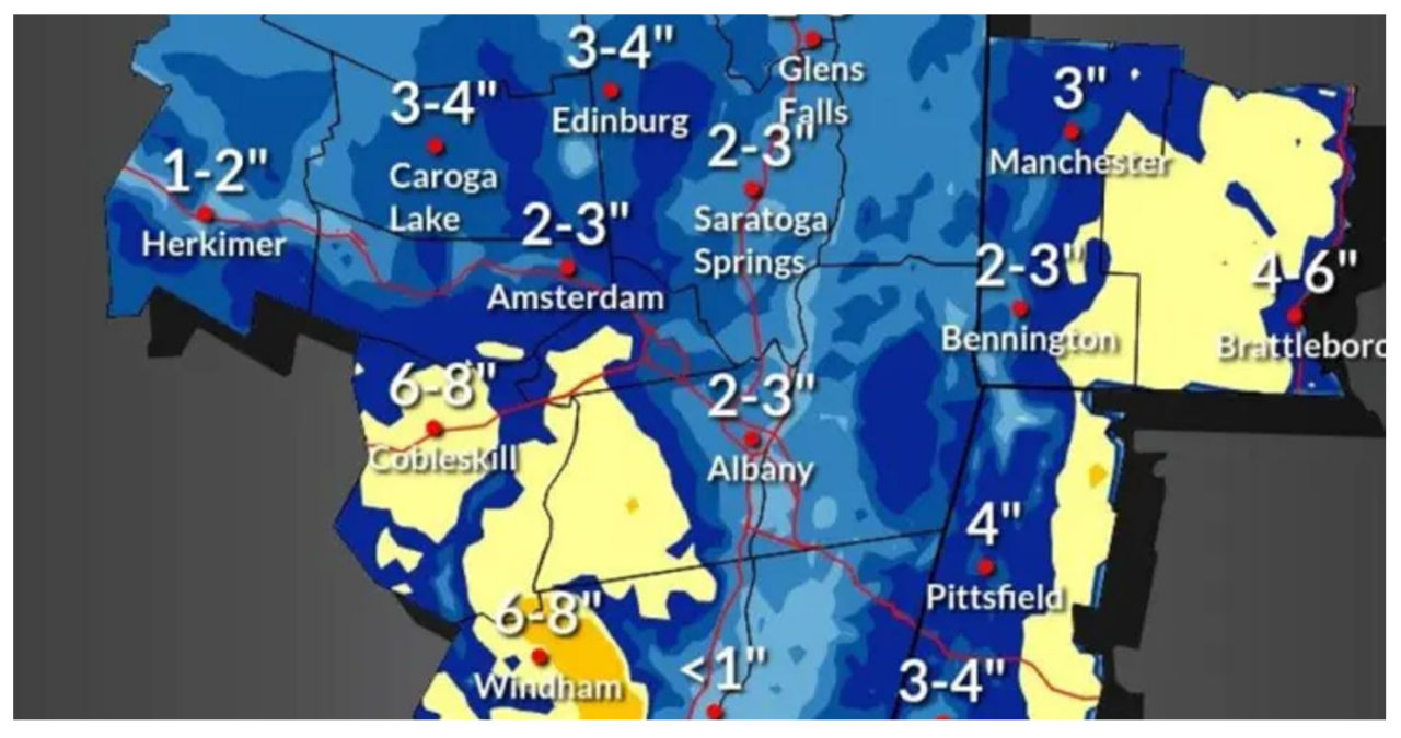
According to the National Weather Service, the areas highlighted in yellow and orange in the first image above could potentially experience snowfall of 6 inches or more.
The National Weather Service stated that the amount of snow will vary based on elevation due to the marginal temperatures. They also mentioned that there is a higher likelihood of receiving 4 or more inches of snow in the eastern/northern Catskills, Berkshire County in Massachusetts, and the region stretching from the southern Green Mountains in Vermont to north-central Massachusetts.
In these areas, it is possible to receive up to a foot of snow.
In the southernmost regions, including New York City, Long Island, and coastal New England, a combination of snow, sleet, and rain is anticipated.
According to AccuWeather.com, the second image above provides the latest snowfall projections. The areas in the darkest shade of blue are expected to receive between 6 inches and a foot of snow. The parts of the region shown in Columbia blue are projected to see 3 to 6 inches of snow, while the areas in sky blue can expect 1 to 3 inches of snow.
Saturday, January 27 is expected to be dry after a series of rainy days. Although clouds will still be present, there will be intermittent sunshine throughout the day. The temperature will reach the mid-40s, providing a relatively mild day. However, it is important to note that the unsettled weather will make a comeback overnight, leading to potential changes on Sunday.
Sunday is expected to be a chilly and damp day, with cooler temperatures and intermittent rain throughout the day and into the night. The storm is set to arrive during the evening hours.
Sunday’s high temperature will reach the upper 30s to around 40 degrees before dropping below freezing overnight.
The temperature on Monday will remain constant around the freezing mark to the mid-30s, accompanied by mostly cloudy skies.
Tuesday, Jan. 30 is expected to be mostly sunny and cold, with a high temperature in the mid-30s.
Wednesday, January 31 is expected to have partly sunny skies with temperatures reaching the mid to upper 30s.